
Enhancing Geological Mapping through Inpainting of Surface Infrastructure Artefacts
Published:
Remote sensing data such as aerial and satellite imagery serve as valuable tools for mapping geological features. However, these datasets often present statistical limitations by capturing only the surface of the Earth. This limitation becomes pronounced when regions of interest, such as economic mineralization or specific geological formations are studied mainly because surface infrastructure artefacts, including mines, roads, dams, and drill pads, inadvertently influence the signature within the imagery. Such non-geological artefacts interfere with machine learning models when focused on geological responses, necessitating the masking or removal of these artefacts.
In this project, our goal is to develop an algorithm capable of replacing these artifacts with realistic data, presenting a superior solution to merely removing or masking them. To achieve this objective, we leverage latent diffusion models for inpainting the missing and corrupted segments of the input data.
Enhancing Geological Mapping Through Inpainting of Surface Infrastructure Artefacts
Recent advancements in machine learning and image processing demand comprehensive datasets devoid of missing data. To address this challenge, various imputation methods have been developed for inpainting missing spatial data. Among these methods, diffusion techniques emerge as modern, state-of-the-art approaches for inpainting data based on surrounding geological context.
In the field of computer vision and artificial intelligence (AI), existing inpainting models, including diffusion models, are predominantly designed for processing natural images composed of the standard red, green, and blue (RGB) colour channels. However, in remote sensing applications, image data often consists of more than just the three RGB bands. This expanded dataset may include numerous spectral bands, each providing valuable information about the geological features present.
Multi-channel Inpainting Model for Data Cleaning
Traditionally, one approach to address this complexity involves treating each spectral band as a separate greyscale image and training individual inpainting models for each band. While feasible, this method overlooks the potential benefits of leveraging the inter-band relationships inherent in multi-band imagery. A more effective strategy entails training a single inpainting model capable of processing all bands simultaneously. By doing so, the model can better exploit the intricate relationships between spectral bands to inpaint missing regions in a more realistic manner.
Despite the advantages of this unified approach, existing AI frameworks often lack support for images with more than three bands, limiting the applicability of traditional inpainting methods in geological contexts. To address this gap, we have developed an advanced inpainting model specifically tailored to handle images with an arbitrary number of spectral bands. Our model not only overcomes these technical limitations but also enhances the accuracy and versatility of inpainting tasks in geological imagery analysis.
This porject underscores the significance of inpainting methodologies in enhancing the accuracy and reliability of geological mapping based on aerial and satellite imagery. By effectively removing surface infrastructure artefacts and inpainting missing spatial data, these techniques enable more precise prospectivity mapping and facilitate the advancement of geological understanding and exploration strategies in diverse landscapes.
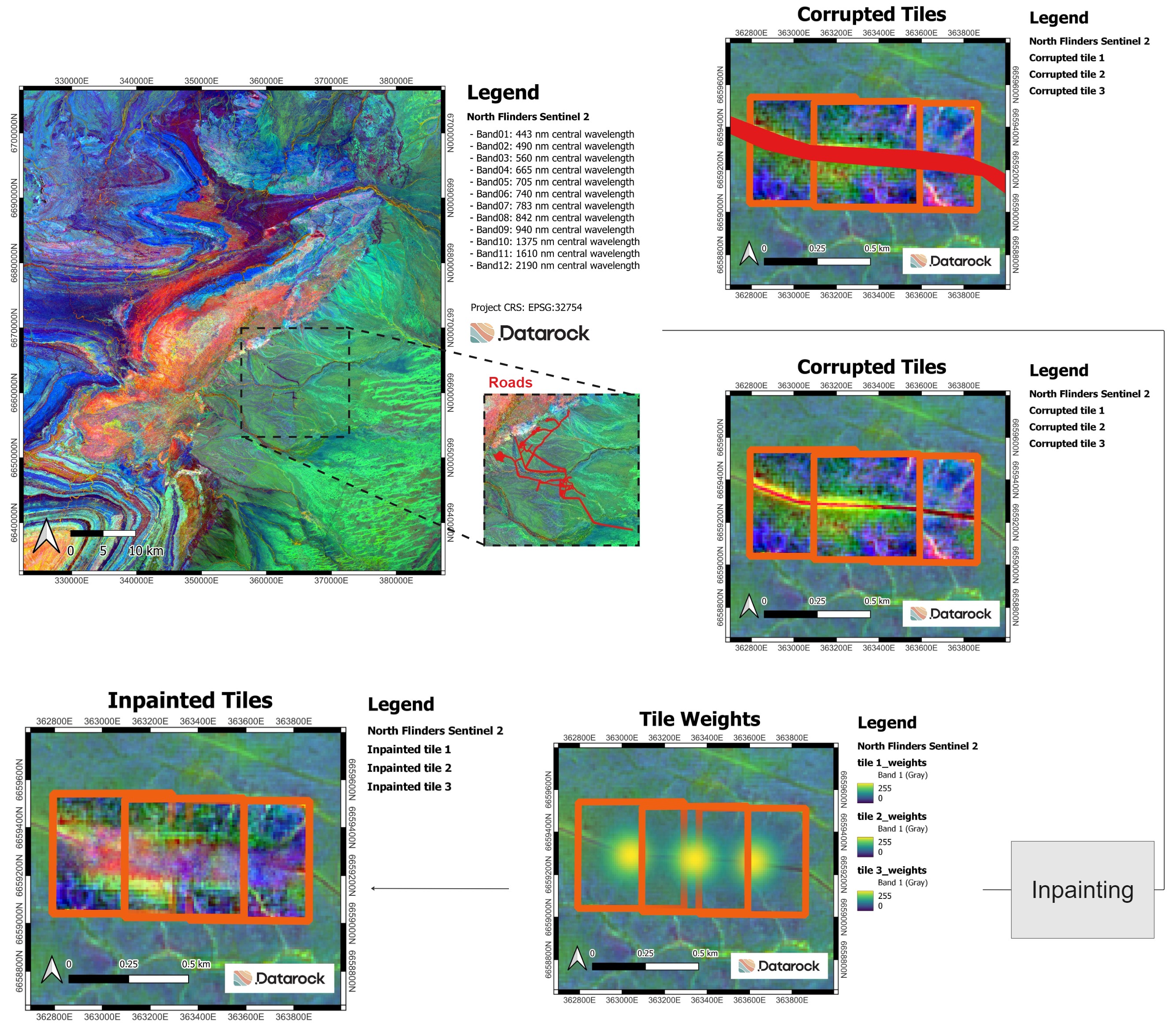
Figure above shows how our multi-channel inpainting model is used to inpaint the roads in the 12-channel multispectral imagery (Sentinel-2) data of North Flinders range with realistic data. Once the input data is cleaned, further advanced AI models are applied to the cleaned data for mining and exploration purposes.
Downstream Tasks after Data Cleaning
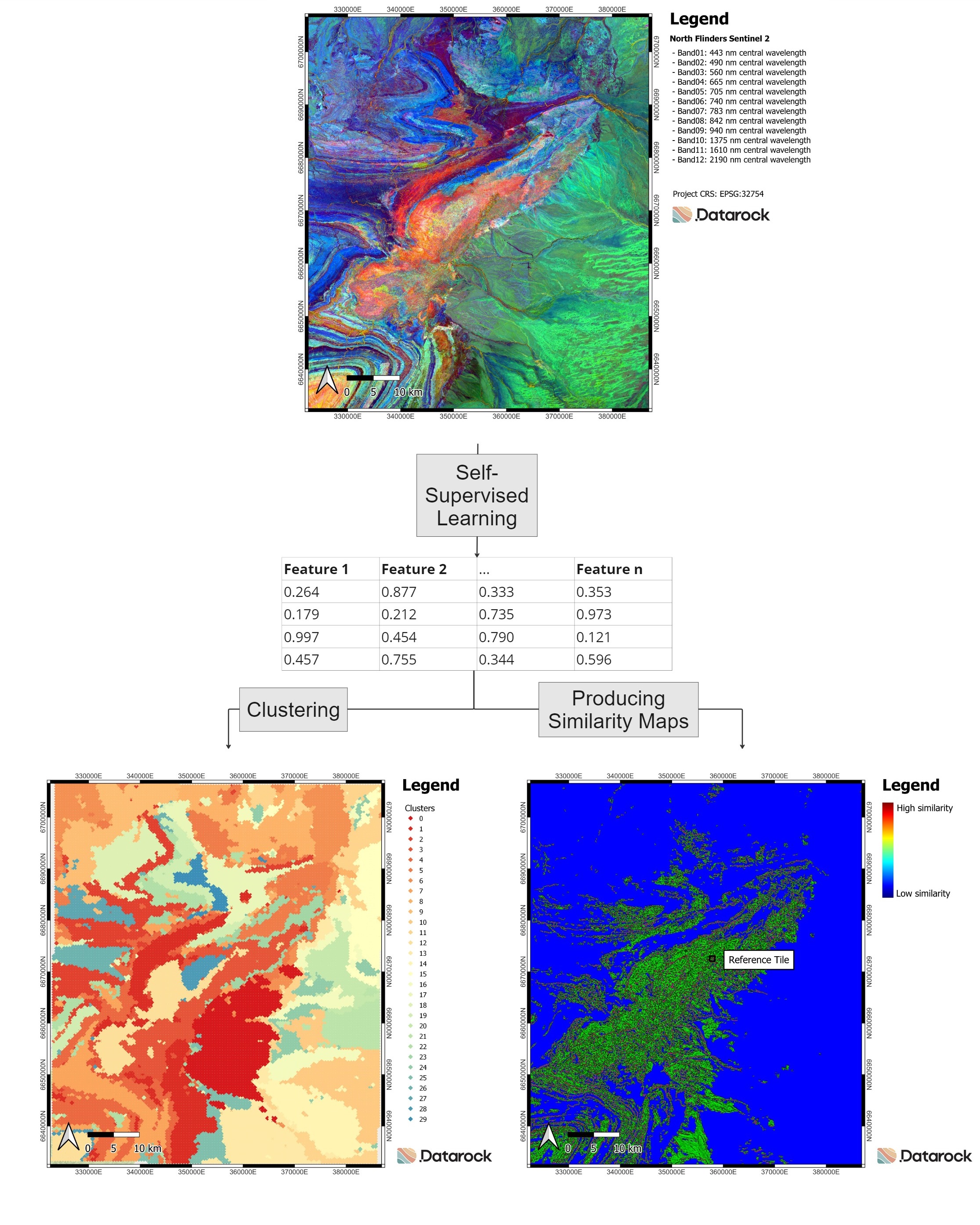
One of the widely used AI models in many of our projects is our self-supervised learning model that is custom-built for analyzing geological imagery. By leveraging our innovative multi-channel self-supervised learning approach, we’ve been able to extract invaluable features. These features play a pivotal role in downstream tasks such as clustering (see Figure below), which enables the identification of similar geological features or creation of similarity maps that point out regions that have similar attributes as a reference region.
Conclusion
In this blog, we introduced a multi-channel inpainting model tailored specifically for geological imagery. Our proposed model performs geological imagery data cleaning by inpainting areas with missing data or surface infrastructure artefacts such as mines, roads, dams, and drill pads.